Climate-Informed Crop Yield & Irrigation Projections for the ACF River Basin
This project integrated soil, crop, and meteorological datasets with the DSSAT Cropping System Model (DSSAT-CSM) to assess how climate will reshape agricultural production and irrigation demand across the Apalachicola–Chattahoochee–Flint (ACF) River Basin. The analysis focused on four major crops— peanuts, corn, soybeans, and cotton—and examined yield sensitivity across normal, dry, and wet years.
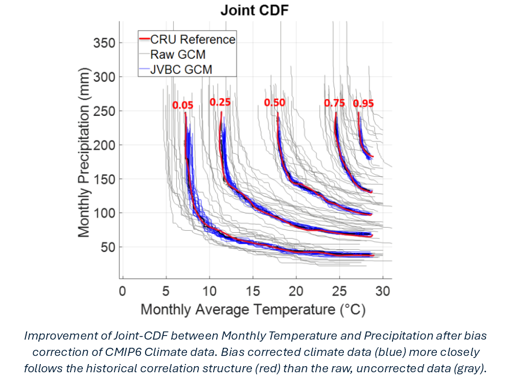
A Joint Variable Bias Correction (JVBC) algorithm was applied to CMIP6 climate projections, producing high-resolution, bias-corrected temperature and precipitation fields suitable for driving DSSAT and downstream regression models. These climate-informed projections were then used to estimate future crop yields and irrigation demand through the end of the century, providing decision-makers with actionable evidence for drought management and water-resources planning.
Background & Problem Statement
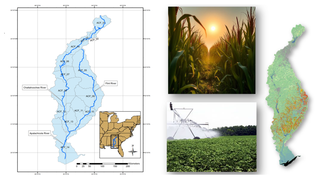
The ACF River Basin is an agricultural and hydrologic “hotspot,” where irrigation, municipal demand, ecosystem needs, and interstate water-sharing agreements intersect. Shifts in growing-season rainfall and evaporative demand directly affect crop yields and the volume and timing of irrigation withdrawals.
Historically, growers and water managers relied on station-based climate records and rule-of-thumb irrigation scheduling. However, with intensifying heat, altered precipitation patterns, and more frequent agricultural droughts, this approach is no longer sufficient to plan for the next several decades.
Problem Statement: How will climate-driven shifts in rainfall and evapotranspiration shape crop yields and irrigation demand in the ACF River Basin, and how can this information be used to guide more resilient farm and water-management strategies?
Model Development
The modeling framework combined detailed agricultural inputs with advanced climate data processing and crop simulation:
- Data Collection: Assembled soil, land-use, and weather inputs from multiple public datasets including the USDA Cropland Data Layer, Climate Research Unit Dataset, GRIDMET historical reanalysis, HarvestChoice soil profiles, and CMIP6 climate projections for the ACF.
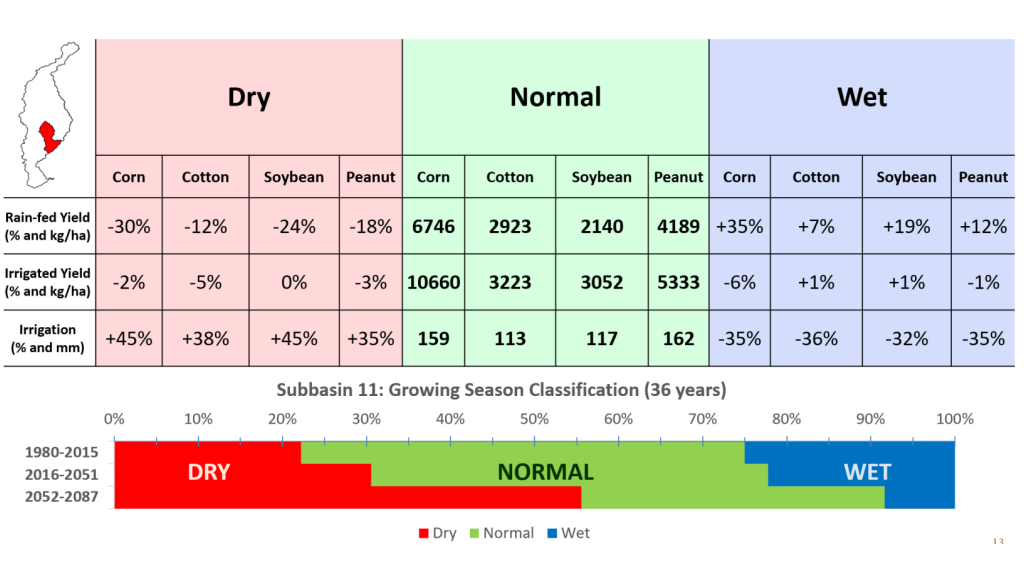
- DSSAT Configuration: Configured DSSAT-CSM for four major crops (corn, cotton, peanuts, soybeans), using region-specific planting calendars, management practices, and soil profiles to simulate yields and irrigation demand under historical conditions (normal, dry, and wet years).
- Joint Variable Bias Correction (JVBC): Developed and applied a JVBC algorithm to downscale coarse CMIP6 projections (~100 km) to ~10 km grid cells and to daily-to-monthly resolution, while preserving the joint distribution and spatial correlation structure of temperature and precipitation.
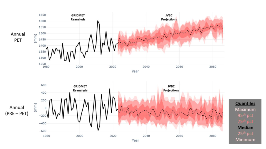
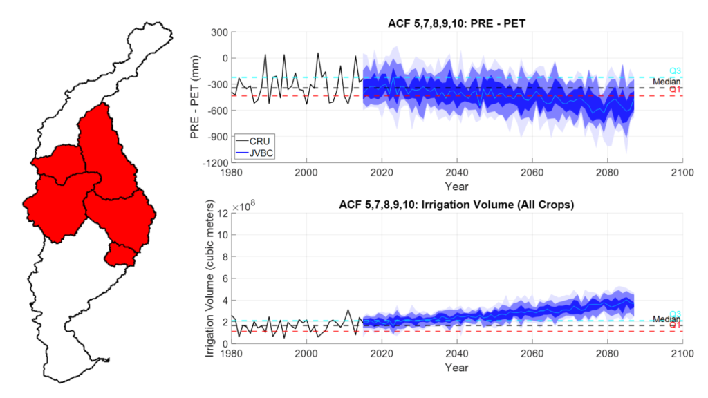
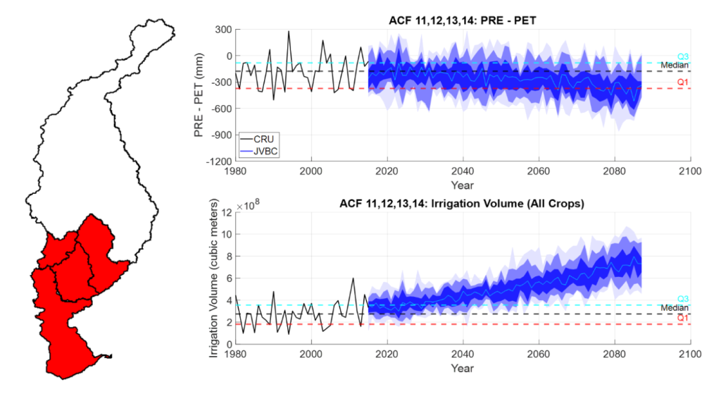
- Derived Climate Metrics: Computed growing-season precipitation, potential evapotranspiration (PET), and precipitation deficit (PRECIP − PET) as primary predictors of yield variability and irrigation demand in heavily cropped sub-regions.
- Regression Modeling: Built regression models linking precipitation deficit to total irrigation demand for each crop and ACF sub-basin, enabling rapid scenario analysis across multiple climate realizations.
Projected Climate, Crop Response, & Irrigation Demand
After calibration under historical conditions, the DSSAT and regression models were driven with JVBC-corrected CMIP6 projections to quantify future climate, crop yield, and irrigation patterns across the ACF.
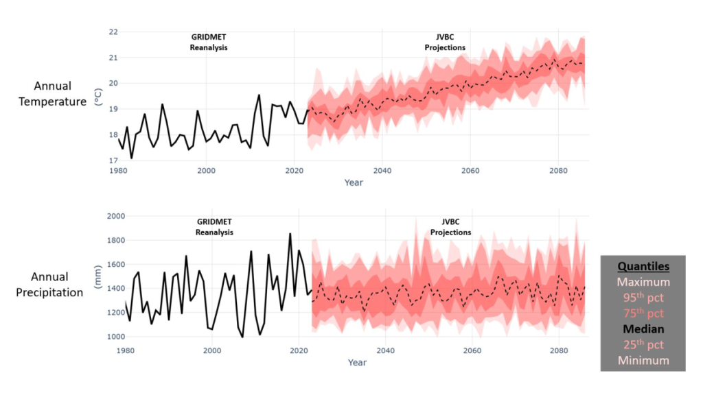
- Projected Climate: Time-series analysis indicates substantial warming across the ACF Basin, while precipitation increases only slightly—insufficient to offset temperature-driven increases in evapotranspiration and atmospheric demand.
- Growing-Season Deficits: Analysis of precipitation deficits (PRECIP − PET) shows that agricultural droughts become more frequent, longer-lasting, and more severe. By the end of the century, over 50% of growing seasons in multiple ACF sub-basins are projected to be classified as “dry.”
- Climate–Irrigation Relationship: Mining historical records revealed a robust functional relationship between precipitation deficit and irrigation demand, which was then applied to future climate scenarios to estimate irrigation requirements for each crop and sub-basin.
- Irrigation Projections: Results show substantial increases in irrigation volumes: Central ACF irrigation demand is projected to rise by ~30% over the next 30 years and ~100% by end-of-century; Southern ACF demand is projected to increase by ~40% and ~130% over the same horizons.
Impact & Actionable Insights
The climate-informed crop and irrigation projections generated in this project provide a quantitative basis for long-term water-resource planning and climate adaptation in the ACF.
- Water-Planning Implications: Projected increases in irrigation demand of 30–40% mid-century and 100–130% by end-of-century signal the need for expanded drought contingency planning, reservoir operation strategies, and potential revisions to interstate water-sharing agreements.
- Farm-Level Adaptation: Growers can use sub-basin level projections of precipitation deficit and irrigation demand to evaluate the value of more efficient irrigation technologies, shifting crop choices, or adjusting planting schedules.
- Policy & Risk Assessment: The integrated data products (bias-corrected climate fields, DSSAT outputs, and regression-based irrigation curves) create a foundation for broader climate-risk assessments that connect agriculture, hydrology, and policy in the ACF Basin.
- Reusable Workflow: The JVBC downscaling, DSSAT integration, and regression framework are modular and can be ported to other basins or sectors (e.g., hydropower, municipal supply) requiring climate-informed water-demand projections.