Remote Sensing & ML for Water Quality Assessment at Lake Lanier
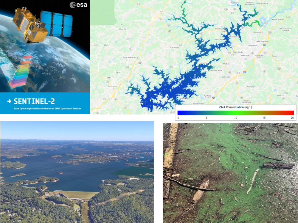
This project developed a satellite-based workflow for estimating chlorophyll-a (Chl-a) in Lake Lanier, Georgia, using Sentinel-2 imagery and in-situ sampling. Chl-a is a key indicator of algal biomass and eutrophication, and is central to monitoring harmful algal blooms and water quality standards compliance.
Traditional field sampling is expensive and sparsely distributed in space and time. By mining satellite reflectance data and learning robust relationships to in-situ measurements, this workflow produces weekly, lake-wide Chl-a maps that give water utilities and regulators a much richer view of changing conditions.
Background & Problem Statement
Chlorophyll-a is widely used as a proxy for algal biomass and trophic state in lakes and reservoirs. Elevated Chl-a levels can indicate harmful algal blooms that threaten ecosystem health, drinking water safety, and recreation.
In Lake Lanier, routine field assessments provide high-quality measurements but are limited in spatial and temporal coverage and require significant field and lab effort. This creates blind spots in understanding how water quality evolves across the full lake surface, especially between sampling events.
Problem Statement: How can satellite-based remote sensing using Sentinel-2 imagery be used to assess and monitor chlorophyll-a concentrations in Lake Lanier, GA, in near real time to improve water quality management and detect harmful algal blooms?
Model Development
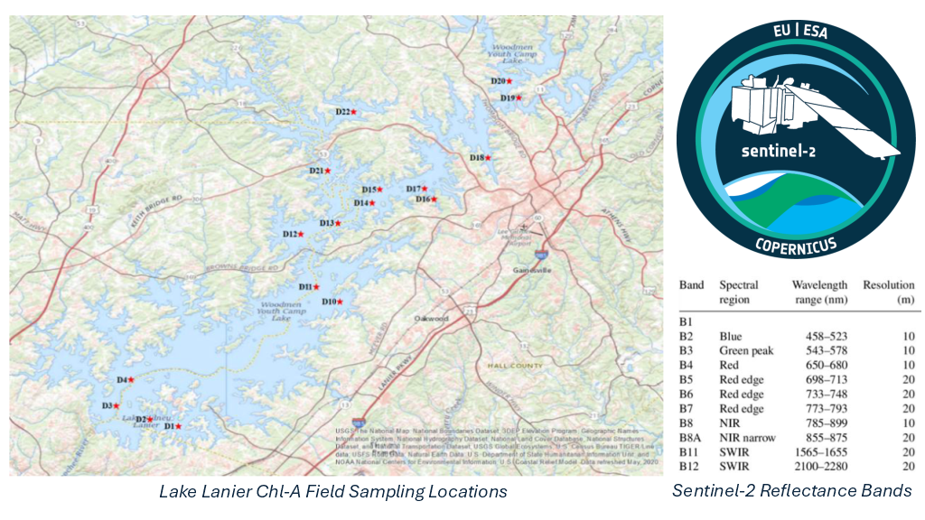
A multi-year lake sampling campaign was conducted from fall 2018 through 2020. During Sentinel-2 overpasses, photic-zone chlorophyll-a concentrations were measured at multiple locations across Lake Lanier. The resulting paired dataset of in-situ Chl-a and satellite reflectance formed the foundation for model development.
- Assembled a dataset linking in-situ Chl-a measurements with Sentinel-2 surface reflectance bands for each sampling location and overpass date.
- Segmented the data by season to account for changing optical properties and stratification in the lake.
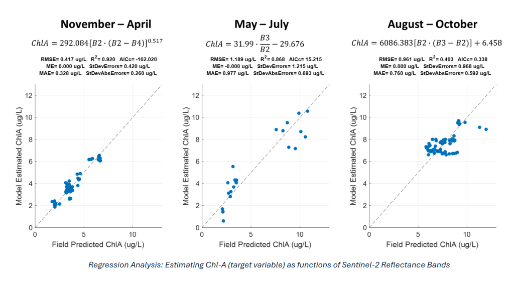
- Applied Symbolic Regression to discover functional relationships between Sentinel-2 bands and Chl-a, identifying the most informative spectral combinations for water quality prediction.
- Evaluated alternative functional forms and seasonal models to balance predictive accuracy, robustness, and interpretability for operational use.
Model Deployment & Results
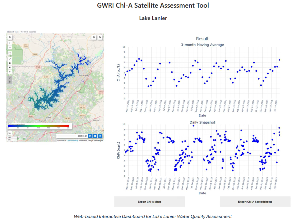
Once robust Chl-a models were established, they were deployed on Google Earth Engine (GEE), enabling near real-time processing of Sentinel-2 scenes and generation of operational water-quality products.
- Implemented the Chl-a estimation algorithms as GEE scripts to automatically ingest new Sentinel-2 imagery, apply atmospheric corrections, and compute lake-wide Chl-a maps.
- Built interactive browser-based tools that allow users to visualize spatial patterns, query locations, and export maps and data tables for further analysis.
- Developed a JupyterLab-based companion workflow for power users, supporting exploratory analysis, time-series extraction, and custom reporting.
- Containerized the full analysis environment with Docker so the tool can be launched consistently on different machines or deployed in cloud / enterprise environments without dependency issues.
Impact & Actionable Insights
The deployed Chl-a Sat-Tool now serves as a decision-support platform for the Gwinnett County Department of Water Resources, providing a synoptic, near real-time view of water quality conditions across Lake Lanier.
- Enables long-term lake monitoring at a fraction of the cost of traditional field campaigns and laboratory analysis.
- Reveals that large areas of Lake Lanier frequently exceed regulatory thresholds for chlorophyll-a, supplying data-driven evidence to prioritize remediation and regulatory compliance efforts.
- Supports early detection of harmful algal blooms by highlighting hotspots and emerging trends between routine sampling events.
- Demonstrates a reproducible, containerized workflow that can be adapted to other reservoirs and regions, accelerating adoption of satellite-based water quality monitoring.
Conference Presentation
I presented this project at the 2021 Georgia Water Resources Conference in Athens, GA, held March 22-23, 2021.